September 30, 2007


In search of Hawk, Kansas.
 Kansas
Hawk, Kansas will not show on any road maps, but it does appear on topographical maps between Anthony and Bluff City along a railroad. You'll find that this railroad doesn't show on road maps, either.
Milton, Kansas.

The road into Freeport, Kansas from the north looks just like the road from the south.

Freeport, Kansas. Only this bit of road in town is paved. Once outside the city limits, the road reverts to dirt. The bank in the corner of the building is still in business. In fact, Freeport claims to be the smallest incorporated city in the United States with a bank.

When you're running well off the primary roads, you can't expect the bridges to be in very good order. In this case, there was a pile of dirt at the approaches to both sides of the bridge. It was no trouble riding around the pile of dirt, and the open gap across to the bridge wasn't more than 9 inches, or so. At least it was still strong enough to support my weight.


Hawk, Kansas is supposed to be here. Somewhere.

I followed the GPS across the field until I was right in the center of Hawk. Nothing. Nothing at all. And, I saw no evidence of tracks. I don't doubt that something was here a hundred years ago, but all traces are now gone.

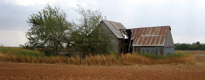
About a 1/4 mile to the east, I saw these old buildings. Is this what is left of Hawk? Possibly.

You can just barely see the remains of pilings in the creek bed. This was the site of the railroad crossing. It's all that I could find. Considering this view, it's possible that a flood removed Hawk.


One of the residential streets in Bluff City.


Aiming towards Caldwell, Kansas (nice clouds).


The Caldwell cemetery.

Caldwell, Kansas.


A self portrait in the window of the high school.

Working my way back north.


Running back to Wichita.
